Search This Blog

Showing posts with label Freedom Tour. Show all posts

Tuesday, October 18, 2016

Wait, Wait -- Follow the What to Where?

I snapped this photo on June 16 of this year. It's a lonesome dirt road on a 171-acre farm in rural north-central Kentucky. 

For years I have known about the private Easley Cemetery on this farm. It includes the graves of my third great-grandfather Joseph Easley Sr. (1764-1849) who established the farm, my second great-grandfather Joseph Easley Jr. (1805-1883), their respective wives and many of their offspring.

I wrote a little more about them in this blog post last week.

These are photos of Joseph Easley Jr. and his wife, my second great-grandmother Elizabeth McWilliams Easley (1818-1894). I love the spectacles resting on her forehead.


My bucket list has included a visit to the cemetery if I ever got an opportunity to travel to Kentucky. That opportunity presented itself at last during my Freedom Tour last summer.

I found driving directions to the Easley Cemetery on the Church and Cemetery Locator online:

"Go to Harrisonville. Just before entering the town from the west turn right into the farm owned by Thomas Lewis. Follow gravel farm road for 600 ft.  Cemetery is in a grove of trees about 30 ft. south of this point." 

I looked on Google Maps and saw that Highway 395/Waddy Road, in the middle of nowhere, leads to Harrisonville from the west. Off I went! So far, so good.

But then everything changed.

"Just before entering the town": As it turns out, there is no town anymore. It hasn't been an incorporated community since 1908. There is just a smattering of houses, farms and a church. No businesses. No Main Street. 

Just the little backwoods Highway 395/Waddy Road.

So which gravel road was I supposed to look for? And on which side of Waddy Road? And which farm belongs to Thomas Lewis? I drove up and down...and up and down...and up and down Highway 395/Waddy Road. Finding this needle in a haystack was impossible.

I did find the church I knew my Kentucky Easley ancestors attended. Joseph Easley Sr. was among a council of elders that on March 12, 1825, founded the Pigeon Fork Baptist Church, which is still in operation to this day. 


And this church that was abandoned long ago (click on it to see the cool windows):


I never found a gravel road based on the driving directions to the Easley Cemetery so I did the next best thing: I followed my amateur genealogist's nose to the Shelby County Public Library in Shelbyville, about 20 miles northwest of here.

It's a stately, historic building constructed in 1903 with a $10,000 grant from philanthropist Andrew Carnegie.


I had a nice conversation with J.D. Stucker, a professional genealogist who volunteers in the local history section, and with Shana Schack, the librarian in charge of Reference Services. 

Sure enough, J.D. was familiar with some local Easley family history and showed me some files, and Shana pulled a 1939 reference book for me that has details about every cemetery in Shelby County. 

The book included directions to the Easley Cemetery!

"Go to Harrisonville. Just before entering the town from the west turn right into the farm owned by Thomas Lewis. Follow gravel farm road for 600 ft.  Cemetery is in a grove of trees about 30 ft. south of this point." 

Yep, they were the same, clear-as-mud directions I had found online.

Neither J.D. nor Shana had any idea where the farm is, and Thomas Lewis's name didn't appear in local history books. 

So my next stop was the Shelby County Courthouse in the hopes of learning who owns the farm now and what the actual property address is.


Stewart Shirley is the deputy administrator in the Property Valuation Office. I told him this was my last best shot and I didn't know where else to turn.

He kindly took me to his office and began a search of county property records in a database that required a lot of work on his part since the only ways to search are by (1) property address, (2) parcel number and (3) current owner's name -- none of which I had, and the database doesn't include historical property records. 

I couldn't provide him with a thing except the 77-year-old driving directions. 


He finally started pulling up aerial images of farms on Highway 395/Waddy Road, looking for anything that might even remotely fit the description in the driving directions. After about half an hour he was sure he had a hit! He had me look at his screen, and I, too, decided this had to be the one. 

He gave me a printout with everything I needed to know for finding the farm and then some.


The next morning, after I returned to the middle of nowhere from my hotel in Louisville 45 miles away, I entered 7651 Waddy Rd. into the GPS on my phone and drove along slowly until the magic voice on the satellite said, "Your destination is on the right."

There was a farm, all right, but there wasn't a gravel road in sight. In fact, there was no entrance of any kind in sight, A property of 171 acres is vast. So I drove farther, slowly, down Highway 395/Waddy Road, looking for a mailbox on the right side of the street or anything else that would indicate an entrance of any kind to 7651 Waddy Rd.

And then I saw it: The mailbox is on the opposite side of the street from the farm, and more than half a mile from where the GPS lady's voice told me I had arrived.  


And it was right across from a narrow, private road that starts out as asphalt and then becomes dirt -- not a speck of gravel anywhere.

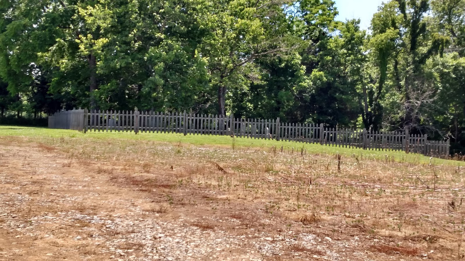
I turned in and followed the dirt road (I was on that road when I snapped the photo at the top of this post). I followed it quite a long way until it curved to the left. 

And there, on the right, set back in a grove of trees, were headstones surrounded by fencing. 

There wasn't a single living soul in sight. I drove past the cemetery and continued down the dirt road in hopes of finding a farmhouse where I could ask permission to visit the cemetery. I finally backed the car up and set about exploring this incredible family treasure.


Joseph Easley Sr. and Catey Deatherage Easley's (my third great-grandmother, 1767-1850) graves are marked simply with rough-hewn stones. I suppose at one time there may have been discernable markings on them.


Joseph Easley Jr.'s is more elaborate (click on it to see detail).

The inscription reads:

Joseph Easley Jr.
Born Mar. 18, 1805
Died Feb. 28, 1883
Not lost, blessed thought.
But gone before
Where we shall meet
To part no more.

I'll leave you with this one: Col. Merideth Hieatt (1785-1868), one of Joseph Jr. and Elizabeth's sons-in-law. 


The cemetery is just a short walk across a field from the narrow dirt road (that's my car). I stayed outside the fence the entire time.


Kenneth and Linda Pratt, the current owners of the farm, are not related to the Easley family. After I returned home to Pasadena from my Freedom Tour I wrote them a note thanking them for maintaining the Easley Cemetery so beautifully. 

As the current keepers of this hallowed ground, I appreciate their dedication to this Easley family treasure. I was sorry I didn't find their house.

May the Easley Cemetery continue to be honored and respected for many generations to come.


All photos were shot by yours truly.

Wednesday, August 17, 2016

Freedom Tour -- Some Didn't Make the Cut

I took more photos with my phone than I could ever possibly include on my blog posts and Facebook posts during my eight-week Freedom Tour, so I've chosen a handful of favorites to share with you that didn't make the cut in the first rounds.

On one of the roads at Yellowstone National Park in Wyoming, traffic was stopped for about 20 minutes due to street repair, so we all just waited patiently in our cars and tour buses. At one point, seeing some movement in my peripheral vision, I looked to my right and saw the bison above just settling in to relax in a clearing next to the road, not caring one whit about the crazy human animals in the hulking steel contraptions. 

I love this shot at Yellowstone because I had pulled over and strolled quite a way along this spot, taking in the wondrous sights of mountains, the river, the dramatic sky and the open plains as well as the sounds of wildlife and rushing water. 


In Shamrock, Texas, with a population of just 2,029 residents, this incredible art deco-style former cafe and service station has been beautifully preserved and is on the National Register of Historic Places. It has a particular pop culture claim to fame: It was the inspiration for Ramone's Body Shop in the fictitious town of Radiator Springs in the Disney film "Cars." I was pleased to see vintage cars and trucks parked at the real location. The building was donated in the late 1990s to the City of Shamrock, which restored it to its former glory with the help of a major grant. The city planners and the city council found a good adaptive reuse for it: It is now the home of the Shamrock Chamber of Commerce.


Deadwood is in the Black Hills of South Dakota. Many structures are built into steep hillsides, including this private residence.


I had no idea the U.S. Marine Corps has a mountain warfare training site in the Eastern Sierras. Oo-rah!


This Civil War mural is on the side of a building in Munfordville, the county seat of Hart County, Kentucky. The population of Munfordville is 1,615. Kentucky was a critically important state during the Civil War.


I bought most of my food in grocery stores. My go-to lunch almost daily was a Nutzo and organic honey sandwich on seed bread with a piece of fruit. (I'm salivating as I write this!)


To get from Elko, Nevada, to Ely, Nevada, it's a three-hour drive down lonesome and winding Highway 93. I added a couple of extra hours to that trek because I wanted to see the remote Lamoille Canyon, known as the Grand Canyon of Nevada. I'm so glad I did!


I'll leave you with one last photo -- Churchill Downs in Louisville, Kentucky, where no racing was taking place that day but tours were being conducted. I took a backstage tour of sorts, then drove around the outskirts of Churchill Downs and was awestruck by the beauty of all the stables and training areas for thoroughbreds. What magnificent beasts (and I say beasts in a good way!)


I loved my Freedom Tour!

I have one final Freedom Tour adventure to tell you about -- a quite unusual one, full of mystery and intrigue. I'll try and get to that next week. Stay tuned...


"Cars" image courtesy of Walt Disney Pictures. 

Saturday, July 23, 2016

Freedom Tour -- Half-faced Selfies Revisited


Well I'm a-standin' on a corner in Winslow, Arizona...

In Winslow, on historic Route 66, there is a downtown corner dedicated to the line in the iconic Eagles song but it was crawling with visitors when I was there -- a total tourist trap where photo opportunities with a statue plus stores selling tacky souvenirs abound. So in the selfie above I decided to pay my own respects in a more authentic way, simply going a few blocks farther to a less busy corner.

That was the first selfie I took on my Freedom Tour. I decided I wanted it to be more about the location and less about me so I cropped it to show only half of my face, then posted it on Facebook. A ritual was born!

For the selfie below, I walked a good, long way to get from Route 66 outside Amarillo in the Texas panhandle to be close enough to Cadillac Ranch to take this selfie. Over the years visitors stole the tailfins and other car parts and graffitied the caddies, which was perfectly OK with the property owner, an eccentric billionaire. 

I snapped this image from my car to show how far from the road Cadillac Ranch really is:

After visiting with my cousins Cab and Kelly Craig for a day and a night in Edmond, Oklahoma, I got back on Route 66 and, at their recommendation, stopped by Pops in Arcadia. It's part gas station, part diner and part craft soda pop emporium.

I decided on an orange soda for the road. This is just a fraction of the brands of orange soda available at Pops!

I had to leave historic Route 66 to head east instead of following it toward Chicago. In Little Rock, my cousin Cynthia Ragan took me to the William J. Clinton Presidential Center. I took this selfie in front of Bill Clinton's iconic saxophone

In Memphis, Tennessee, I met up with my sister Charlou and our lifelong friend Joanna. Joanna was visiting Charlou in Bella Vista, Arkansas, when they decided to come to Memphis because Joanna had never been to the South before.

We went to the Port of Memphis for a two-hour cruise aboard the Island Queen.

Here she is in all her glory. Many locals call the Hernando de Soto Bridge in the background the Dolly Parton Bridge. I can't imagine why!

Two days later, when Charlou and Joanna returned to Arkansas, I headed over to Graceland with the goal of visiting SiriusXM's Elvis Radio and meeting one of the DJs, Big Jim Sykes. Jim has been one of my warriors during my adventures in breast cancer. This may seem unlikely to many -- a radio DJ in Tennessee, whom I had never met, cheering me on throughout my battle -- but Facebook sometimes brings people together in unlikely ways.

It was just wonderful to finally meet him, and he gave me the biggest hug and warmest welcome! By the way, his wife is a breast cancer survivor, God bless her.
In Nashville I visited the Grand Ole Opry and took a fun backstage tour.

Near Hodgenville, Kentucky, I visited the birthplace of Abraham Lincoln. That memorial in the background was constructed long before the one in Washington, D.C. I included my visit in this blog post.

The massive Kentucky Floral Clock is a public art installation in Frankfort, Kentucky.

A few miles outside of Frankfort, I came across the historic Switzer Covered Bridge that spans the north fork of Elkhorn Creek. It was built in 1855 and is on the National Register of Historic Places. 

With so many baseball fans among family and friends, I had to stop by the Louisville Slugger Factory and Museum when I was Louisville, Kentucky
Each of the regulation bats begins with a piece of Northern White Ash grown in proprietary forests on the New York/Pennsylvania border.

The windiest day of my Freedom Tour by far was in St. Louis, Missouri, but I got the money shot anyway -- windswept hair and all!

I went south to Bella Vista, Arkansas, in the spectacular Ozark Mountains for a visit with my sister Charlou and her husband Bill. It was great to get together with my cousins Bonnie Sutton, Judy Galloway and Judy's husband Ken as well. I shot this selfie from the upstairs deck at Charlou's house, which is on beautiful Lake Avalon

In South Dakota I stopped in Sturgis. The annual motorcycle rally isn't until next month so there wasn't much going on but at least I can say I was there.

Mount Rushmore in South Dakota is quite dramatic and was an emotional experience.


On the way down the mountain I came across George Washington's profile.


Along a lonesome two-lane highway in Wyoming I saw a sign for Devil's Tower and couldn't possibly pass up the 20-mile side trip. I didn't have any close encounters of the third kind, though.

The Central Pacific Railroad and Union Pacific Railroad were joined in an engineering feat in 1869 at Promontory Summit in what was then the Utah Territory, completing the final link of the Transcontinental Railroad. My visit to the Golden Spike National Historic Site was another long side trip that was well worth the drive. 


The Great Salt Lake near Salt Lake City and Ogden, Utah, is the largest salt lake in the western hemisphere. That's not shoreline you see in the background; it's an island. The lake spans nearly 2,000 square miles. 


In Ely, Nevada, my namesake restaurant, lounge and casino is for sale. It's still open for business, though.


If I ever need to supplement my retirement income, there may be a job available at this brothel in Amargosa Valley, Nevada, not far from Area 51.

My last selfie: Death Valley, which was not exactly teeming with tourists in the middle of July!


I loved my Freedom Tour!